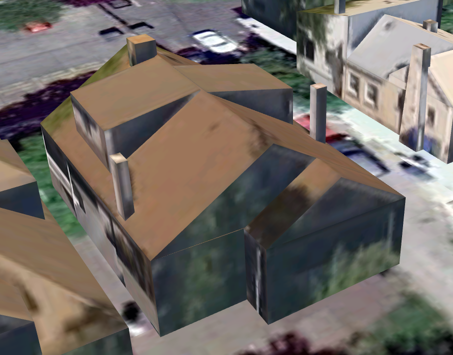
Although I use Google Earth fairly often, I generally leave “3D buildings” turned off since my machines tend to have the crappiest possible graphics cards. But the other day I randomly turned it on and was surprised to find that Salt Lake City is now heavily populated with building models, even including some residential neighborhoods. The house above is the one that Sarah and I lived in between 2001 and 2008. At some level this model is poorly done: the front and side porches are rendered as blocks and the textures mostly just show the trees that prevented the Street View van from seeing the house. On the other hand, the model is impressive in that it got the sizes of the dormers right, both chimneys are there, and the swamp cooler (the block on the roof behind the dormers) is just about right. The rest of the houses in the neighborhood are similarly rendered.
At this point I started to wonder: Who is it that put a model of my old house into Google Earth? The model was uploaded by “buildsaltlake2,” an entity that lacks a Google profile but has uploaded more than 12,000 models. Clearly someone is systematically machine-generating and uploading models. Is this going on everywhere? Does anyone know the technology involved? It has to be based on pictures because any data on this 110-year-old house in the city offices would be sorely out of date, and wouldn’t know about the swamp cooler in any case. Also I assume there’s a profit motive, but don’t know what it is. Here’s a link to the view above.
8 responses to “Google House”
It may be the city (i.e. municipal or local government) of Salt Lake City, or someone using digital public records from the local government which could have the building records (property taxes, building permits, zoning) digitized and linked to the GIS system providing Geo-referencing of the associated information. My current local city (pop. ~40,000) has partial records available.
The other option I can think of would be a large scale 3-D (laser) scanning, which may of been done with or similar to Google StreetView image collection, though that is limited to street visible (in reference to the image above, I wouldn’t expect it to be that good on the rear of a building).
If you have multiple aerial photos taken at different sun angles, are there any well known algorithms that would allow you to estimate the basic 3D geometry by measuring shadow shape, position, and area? It seems like that should be doable but I’m not certain…
Hi msalib, I think it must be something like that. I used to hack photogrammetry codes and I know that amazing things are possible.
As Michael observes, some of the roof details would be very hard to discern from the street, even with a good laser rangefinder.
Michael, I strongly doubt (but of course cannot be sure) that the city has any current records of the shape of this house.
Looking at the Merrill Engineering Building, and my office specifically, the trees are way too low. I am on the 3rd floor, and I don’t see out of the window because of them. But in the 3D model, the trees barely reach the second floor. So the pictures were certainly taken from a airplane.
I also noticed that google maps recently introduced bird eye views if you zoom close enough in the satellite view. Maybe they just use multiple pictures to create these approximate 3D images?
Hi Thomas, I agree. Based on my old house (where the trees aren’t very tall) I was guessing street-level imagery but actually there are some really tall trees across the street that must be showing up. Also, this house model shows detail on the side and back that simply cannot be seen from the street. So my current best guess is 3d reconstruction from multiple aerial photos.
Here’s a paper that describes an algorithm that infers building structure from multiple aerial views: http://www.cs.purdue.edu/cgvlab/papers/aliaga/cvpr10-urban.pdf
I would guess synthetic aperture radar
Am I the only one extremely annoyed at Google peeking over my back fence?